
Terrestrial Information Management
Staff

Research Topics
Study on rural environment using terrestrial information processing
|
In recent years global environmental problems such as desertification, the forest decrease, the degradation of the farmland have become serious, also in our imminent place, local environmental problems such as the Satoyama landscape(rural landscape) have become serious. These environmental problems have large or small spatial scale, but those are all phenomenon occuring on the real field, and the thing which can describe such spatial phenomenon is a map (geography space information). In our laboratory, we have been trying to analyze various environmental problems using a digital map and the artificial satellite image which we can treat with a computer. |
|
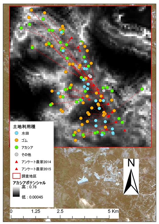
Monitoring of land use/cover change and mathematical modeling
|
Land use/cover is greatly influenced by local environment and has a significant influence at the same time to area environment, also greatly influenced by the global environment and have a significant influence on the global environment. When thinking about local and global environment, It become fundamental problem how to control land use/cover. This study aims to bring useful result for planning, to make clear the cause and effect relationship of land use/cover change by modeling it. |
|
Publication List
- The Japanese Society of Irrigation、Drainage and Rural Engineering Edition(Hidenori Morita and others)(2019):Dictionary of standard terminology for irrigation, drainage and rural engineering
- Hidenori Morita(2019):Lessons from Heavy rain in July 2018 -Toward the community improvement resisting a disaster -, Journal of Rural Planning, Vol.37, No.4, 366-368
- Mengxian Liu and Hidenori Morita(2019)Vulnerability assessment of ecological system using GIS in Huaian City, Jiangsu province, China, JSIDRE Chugoku Shikoku Branch, 64-66
- Hidenori Morita(2018)Hilly and Mountainous Areas to shine in the current of the times, Water, Lnad and Environmental Engineering, Vol.86/No.11,pp.1-2
- Hidenori Morita and Takeo Akae(2017):, Spatial geographical features of land where salt accumulation tends to be caused -An empirical study using field observation data in Hetao Irrigation District, Inner Mongolia Autonomous Region, China- New developmention agriculture Green field, 701, 15-23
- Hidenori Morita and Takeo Akae(2017): An attempt to classify land cover of upland fields in arid region using multiple satellite images -A case of Hetao Irrigation District, Inner Mongolia, China-, New developmention agriculture Green field, 700, 11-19
- Hidenori Morita, Shoya Hironaka and Yuki Matsumoto(2017):Geospatial Preference for Asparagus Fields in Thailand, Journal of the Faculty of Environmental Science and Technology Okayama University, 22(1), 65-71
- Hidenori Morita(2015):From GPS survey to GNSS survey, Water, Lnad and Environmental Engineering, Vol.83/No.6 492